This project aims at leveraging the capabilities of state-of-the-art surveying technology for efficient mapping of shallow seafloor bathymetry and benthic cover.
CONCEPT: The main concept is to combine drone-based multi-spectral imagery covering large portions of shallow coastal seafloor with unmanned surface vehicle (USV) bathymetry measurements for bathymetry mapping over wide-scale coastal areas.
CURRENT STATUS: At the moment, shallow seafloor remains highly unmapped and this is mainly due to several issues, including: a) minimum operational depth of traditional boat surveys, b) low swath coverage of sonar sensors over very shallow waters, c) mobilization costs and time requirements for traditional sonar surveys to perform large-scale comprehensive mapping of shallow seafloor.
INNOVATION: The innovative aspect of this project is the utilization of both structure-from-motion and spectral analysis techniques simultaneously for deriving an accurate 3D model of shallow seafloor. These techniques will be complementing each other during processing. Seafloor types with texture are rich in geometry features that allow for extracting a highly detailed 3D model which can further be applied to the spectral data for final bathymetry retrieval. Alternatively, seafloor areas without sufficient features will be processed only with spectral analysis for bathymetry calculation.
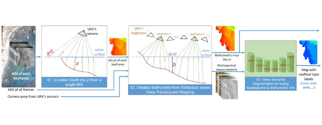
METHODS: The proposed methodology includes fusion of a) 3D point cloud extraction from multi-view stereo point matching together with b) empirical models for bathymetric calibration of multi-spectral imagery (Stumpf et al., 2003). USV bathymetry measurements will further assist in compensating for refraction effects (air/water interface) on the 3D point cloud. The workflow will be implemented in the form of a convolutional neural network which is going to be trained with a diverse set of USV bathymetry points and seafloor types.
IMPACT: Deriving large scale bathymetry of shallow coastal seafloor in a time and cost-effective way is priceless. Shallow coastal bathymetry provides valuable base-line information for a wide range of applications including but not limited to:
- Coastal erosion risk assessment
- Coastal hydrodynamic modelling
- Benthic habitat mapping
- Submerged archaeology documentation
- Coastal spatial planning